When sourcing magnetic GPS trackers, understanding how they work is more than just technical curiosity—it directly impacts your ability to evaluate supplier specifications. Knowing why GPS has a cold start delay, why low-power IoT networks consume less power than standard 4G, and how magnetic strength and mounting positions affect signal quality allows you to ask the right questions during the inquiry process.
- A magnetic GPS tracker consists of 4 core subsystems: positioning, communication, magnetic mounting, and power management.
- A GPS cold start of 30-90 seconds is normal; AGPS assistance can shorten this to 5-10 seconds.
- The network mode determines more than just speed—it also impacts power consumption, coverage, and hardware lifecycle.
- 80% of magnetic GPS device detachment issues are not caused by insufficient magnetic force, but by improper selection of the mounting surface.
Four Core Subsystems Inside a Magnetic GPS Tracker
![]()
The hardware architecture of a magnetic GPS tracker can be broken down into four subsystems, each operating independently yet constraining one another:
| Subsystem | Core Components | Problem Solved |
|---|---|---|
| Positioning System | GPS/AGPS/WiFi/BLE | Where is the device? |
| Communication System | 4G / Low-Power IoT Networks / 2G + SIM Card | How to transmit location data back to the platform |
| Mounting System | Neodymium Magnet + Enclosure | Fixed onto the target asset |
| Power System | Lithium Battery + Power Management IC | Maintaining continuous operation |
Understanding the relationship between these four systems is the foundation for evaluating any magnetic GPS tracker. Let’s break them down one by one.
Positioning System — How Does the Tracker Know Where It Is
Positioning is the starting point of the entire system—if the device does not know where it is, the subsequent communication and power management become meaningless. The positioning capability of a magnetic GPS tracker goes far beyond simply “receiving GPS signals.” Technical details such as cold start delays, auxiliary positioning, and multi-constellation support directly impact your deployment experience and device selection.
GPS Satellite Positioning Principles
A magnetic GPS tracker receives signals from at least 4 GPS satellites, calculates the distance between the device and each satellite, and determines the latitude and longitude coordinates through trilateration.
Accuracy: 2-5m in open environments; it may drop to 10-15m in urban areas with building obstructions.
Cold Start vs. Hot Start:
- Cold Start (first-time boot or offline for a long time): The device needs to download the satellite almanac, typically taking 30-90 seconds.
- Hot Start (recently positioned): It only needs to search for known satellites, taking 1-5 seconds.
- AGPS Assistance: Downloads the almanac via the cellular network, shortening the cold start from 90 seconds down to 5-10 seconds.
Buyer’s Insight: If your deployment scenario requires the device to power on and off frequently (to save power), the cold start time directly affects the tracking blank period after each boot. Demand that suppliers provide actual measured times for cold starts and AGPS-assisted starts.
WiFi and BLE Auxiliary Positioning
When GPS signals are unavailable (such as in underground parking garages or inside shipping containers), some magnetic GPS trackers will enable auxiliary positioning:
- WiFi Positioning: Scans the MAC addresses of surrounding WiFi hotspots and estimates the location by matching them against a database, with an accuracy of 50-100m.
- BLE Positioning: Works in conjunction with Bluetooth beacons, suitable for close-range positioning in warehouses and enclosed spaces.
This is not a replacement for GPS, but a supplement—providing a rough location when GPS signal is lost is much better than having no information at all.
Multi-Constellation Positioning (GPS + GLONASS + Galileo + BeiDou)
High-end magnetic GPS trackers support multiple satellite navigation systems:
| Satellite System | Coverage | Visible Satellites |
|---|---|---|
| GPS | Global | 6-12 |
| GLONASS | Global | 5-10 |
| Galileo | Global | 6-10 |
| BeiDou | Asia-Pacific Advantage | 6-14 |
Simultaneous searching across multiple constellations = more visible satellites = faster positioning + higher accuracy + better performance in urban canyons.
Buyer’s Insight: For fleets operating globally, multi-constellation support is a major plus. For operations solely within North America, GPS+GLONASS is generally sufficient.
Communication System — How Location Data Gets Back to You
![]()
Location data is collected, but if it cannot be transmitted back, the device becomes an isolated island. The communication system determines the speed, cost, and reliability of data transmission—and the choice of network mode directly impacts the device’s power consumption and its availability over the next 3-5 years.
Cellular Network Transmission
Magnetic GPS trackers connect to mobile networks via a built-in cellular module to send location data to cloud servers. Data is typically transmitted via TCP/IP or MQTT protocols.
| Network Mode | Data Rate | Power Consumption | Applicable Scenario |
|---|---|---|---|
| 4G LTE | High (can support real-time video) | Moderate | Real-time tracking, high-frequency reporting |
| Low-Power IoT Network | Low (sufficient for location data) | Extremely Low | Long battery life asset GPS tracking |
| 2G GSM | Extremely Low | Low | Sunset phase, new procurement is not recommended |
A Key Difference: Both 4G LTE and low-power IoT networks can transmit location data, but 4G consumes more power. For asset GPS tracking scenarios that do not require high-frequency reporting, the battery life on a low-power network can be 3 to 5 times longer than on 4G.
SIM Cards and Data Plans
- Standard SIM Card: Requires a contract with a local operator, suitable for single-country deployments.
- IoT SIM Card (M2M): Supports multi-country roaming, ideal for cross-border fleets.
- eSIM: Allows remote operator configuration, suitable for large-scale deployments.
Procurement Note: Confirm whether the supplier’s device is locked to a specific carrier. Carrier lock-in means you are tied to the supplier’s data plans, making long-term costs uncontrollable.
For a detailed technical comparison and procurement recommendations regarding 4G and low-power IoT networks, please refer to GreatWill’s 4G Magnetic GPS Tracker Upgrade Guide.
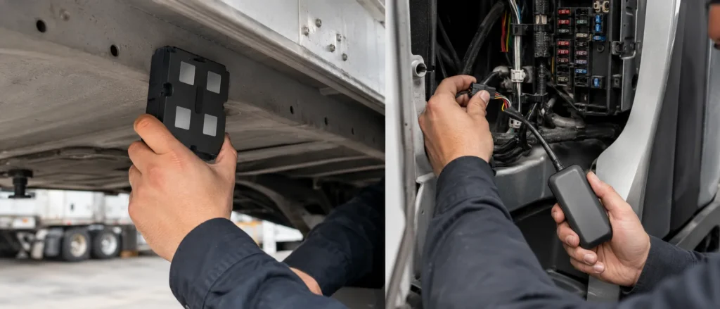
Magnetic Mount System — How Does the Magnet Hold
What distinguishes a magnetic GPS tracker from other mounting methods is the magnet itself—it determines whether the device can be securely fixed to the target asset. However, the “pull force value” is just a surface parameter; the magnet material, temperature characteristics, and the flatness of the mounting surface can all cause the actual performance to fall far below the rated specification.
Physical Properties of Neodymium Magnets
The Neodymium (NdFeB) magnets used in magnetic GPS trackers are currently the strongest commercially available permanent magnet materials. Key parameters include:
- Pull Force Value: Depends on the magnet volume and grade (N35-N52); typically 10-15kg for a single magnet, and can reach 50kg+ with multi-magnet combinations.
- Temperature Stability: Standard N35 begins to demagnetize above 80°C; high-temperature scenarios require selecting N35SH or N35UH grades.
- Corrosion Protection: Raw neodymium oxidizes easily, requiring protection via a Ni-Cu-Ni triple-layer coating.
Impact of the Mounting Surface on Pull Force
The magnetic force values labeled by suppliers are measured on an ideally flat steel plate. In actual deployment, the following factors will weaken the holding force:
| Factor | Degree of Impact | Solution |
|---|---|---|
| Uneven Mounting Surface | May reduce by over 50% | Select flat areas, avoid welds and curved surfaces |
| Surface Dust/Oil Stains | Reduces by 30-50% | Clean the surface before installation |
| Non-Iron Mounting Surface | Pull force is zero | Cannot be used on aluminum alloy or plastic surfaces |
| High Temperature (>80°C) | May cause demagnetization | Select high-temperature resistant magnet grades |
Experience: 80% of magnetic GPS trackers device detachment issues are not due to insufficient magnetic force, but because the mounting surface was poorly selected or uncleaned. Providing field operators with a simple installation checklist during deployment can significantly reduce the detachment rate.
For a comprehensive reliability comparison between magnetic and hardwired mounting methods, please refer to GreatWill’s Magnetic vs. Hardwired GPS Trackers Comparison Article.
Power Management System — Why Battery Life Varies So Much

Battery life is the specification buyers care about most, and it is also the area where suppliers are most likely to inflate numbers. Two devices with the exact same 10000mAh battery can have actual measured runtimes varying from 7 days to 180 days. The root of this difference lies not in the battery cell itself, but in the power management strategy and your usage profile. Understanding the logic of the power management system allows you to see through inflated supplier battery claims.
Lithium Battery Basics
Magnetic GPS trackers widely use Lithium Polymer (Li-Po) batteries due to their high energy density and high malleability (adapting to various enclosure shapes).
With the same 10000mAh battery, the runtime varies drastically under different reporting modes:
| Reporting Mode | Reporting Frequency | Typical Battery Life |
|---|---|---|
| Real-Time Tracking | Every 5-30 seconds | 7-15 days |
| Regular Monitoring | Every 1-5 minutes | 20-40 days |
| Power Saving Mode | Every 1-6 hours | 40-90 days |
| Ultra Power Saving | Once a day | 90-180 days |
The Role of the Power Management IC
The power management chip controls the sleep-wake cycles of the device and serves as the core of battery optimization:
- The device spends most of its time in a deep sleep state (power consumption < 50μA).
- Upon reaching the preset reporting time, the power management chip wakes up the main MCU.
- The device acquires the location → transmits the data → confirms server receipt → re-enters deep sleep.
Each wakeup cycle takes about 5-15 seconds, while the remaining time is spent in sleep. The higher the reporting frequency, the more wakeup cycles occur, resulting in higher power consumption.
Buyer’s Insight: Ask suppliers to provide actual current consumption data under different reporting frequencies. A supplier with genuine R&D capability should be able to provide the exact average current and estimated battery life for each mode.
To learn more about detailed battery optimization strategies and actual test data, please refer to GreatWill’s Magnetic GPS Tracker Battery Life Feature.
How the Four Systems Work Together — A Complete Cycle
We have previously broken down the positioning, communication, magnetic mounting, and power management subsystems. However, in actual operation, these four systems do not run in isolation—they cooperate precisely during every single location report. Any delay or failure in any link will affect the final data transmission. Understanding this complete cycle allows you to judge whether a supplier’s specifications are reasonable and better anticipate issues during deployment.
From Sleep to Reporting — A Complete Positioning Cycle
- Power Management Chip Wakes the Device: Upon reaching the preset reporting time, the power management chip switches the device from deep sleep (power consumption < 50μA) to an active state. The wakeup process takes about 1-2 seconds, which includes powering up the MCU, initializing the GPS module, and setting the cellular module to standby.
- GPS Module Searches Satellites and Acquires Coordinates: This is the most time-consuming part of the entire cycle. A hot start takes 1-5 seconds, while a cold start takes 30-90 seconds. AGPS assistance can shorten a cold start to 5-10 seconds. If the device supports multi-constellations (GPS+GLONASS+BeiDou), the search speed is faster and positioning is more reliable.
- WiFi/BLE Auxiliary Positioning Enables When GPS Signal is Weak: In scenarios like underground parking garages or inside metal shipping containers, GPS satellite signals are blocked. At this point, the device scans surrounding WiFi hotspots or Bluetooth beacons to estimate a rough location via database matching (accuracy 50-100m). Though less accurate than GPS, it is much better than losing contact entirely.
- Main MCU Packages Location Data: Latitude, longitude, timestamps, speed, heading, and battery level are encapsulated into a standard format (usually a proprietary protocol or standard OBD/Location JSON formats) and prepared for transmission.
- Cellular Module Establishes Connection and Sends Data to the Cloud: A 4G LTE connection usually takes 1-3 seconds; low-power IoT networks are slightly slower but consume less power, while 2G is the slowest and has unstable connections. Data is sent to the cloud server via TCP/IP or MQTT protocols. If transmission fails (e.g., network unavailable), the device caches the data to local storage and waits to retransmit during the next successful connection—meaning you will not lose historical tracking data.
- Cloud Server Confirms Receipt, Device Re-enters Sleep: Once the server returns an acknowledgment signal, the power management chip turns off the GPS and cellular modules, and the device returns to deep sleep. If the server does not respond, the device will retry 1-3 times before sleeping to avoid data loss.
Cycle Duration and Influencing Factors
| Scenario | Typical Cycle Duration | Main Time-Consuming Step |
|---|---|---|
| Hot Start + Good 4G Network | 10-15 seconds | GPS Hot Start + Network Transmission |
| Cold Start + Good 4G Network | 40-100 seconds | GPS Cold Start |
| Hot Start + Low-Power IoT Network | 15-25 seconds | Slower Low-Power Network Connection |
| Hot Start + Weak Network Signal | 30-60 seconds | Network Connection Retries |
| Weak GPS Signal + WiFi Auxiliary | 20-30 seconds | WiFi Scanning + Matching |
Procurement Insight: During each reporting cycle, the device is only truly “working” for 10-100 seconds, while remaining in deep sleep for the rest of the time. Changing the reporting frequency from every 30 seconds to every 5 minutes means wakeup cycles are reduced tenfold, dropping power consumption by an order of magnitude—this is the fundamental reason why battery life can multiply in power saving modes.
What Happens When a Step Fails
| Failed Link | Device Behavior | Operational Impact |
|---|---|---|
| GPS Cannot Position | Skips positioning, sends “No Location” status or uses last known position | Tracking blank spots appear |
| Network Connection Fails | Caches data locally, retransmits upon next successful connection | Delayed location receipt, but data is not lost |
| Server No Response | Retries 1-3 times then sleeps, transmits during the next cycle | Brief delay, data eventually arrives |
| Battery Extremely Low | Sends low battery alarm only, enters ultra power saving mode | Requires immediate retrieval for charging |
By understanding each step of a single reporting cycle, you can press suppliers for more specific questions during evaluation: What is the actual measured cold start time in seconds? What is the network retry mechanism? How many offline data logs can be cached? The answers to these questions are far more telling than a simple claim of “90 days of battery life.”
What to Ask Your Supplier About Technical Architecture
Armed with an understanding of how these devices work, you can ask deeper questions during inquiries:
| Question | What You Are Evaluating |
|---|---|
| What is the cold start time? Is AGPS standard? | Whether the positioning speed meets your deployment needs |
| Which satellite systems are supported? | Positioning reliability during global deployments |
| Is WiFi/BLE auxiliary positioning supported? | The ability to handle weak GPS scenarios like underground garages |
| What is the actual battery life data under different reporting frequencies? | Whether the supplier possesses real engineering and testing capabilities |
| Is the power management chip a self-developed or public solution? | Whether the power saving strategies can be customized |
| Is the SIM card carrier-locked? | Whether your data traffic costs remain controllable |
| What are the magnet grades and high-temperature test data? | Reliability under extreme environments |
GreatWill’s magnetic GPS trackers utilize self-developed firmware and power management solutions, supporting full-frequency positioning and flexible reporting strategy configurations. To learn more technical details, please visit GreatWill’s Product Page.
Frequently Asked Questions
Does a magnetic GPS tracker need a network connection to work?
Yes. Positioning relies on GPS satellites (which do not require a network), but transmitting that location data back to your phone or platform requires a cellular network.
Can a magnetic GPS tracker position itself inside an underground garage?
GPS signals cannot penetrate buildings. However, some devices support WiFi auxiliary positioning, which offers an accuracy of around 50-100m—far better than having no position information at all.
Do the magnets on a magnetic GPS tracker interfere with the GPS signal?
No. Neodymium magnets do not interfere with the L-band frequencies used by GPS signals. The magnets only affect compass functions but have no impact on GPS positioning.
Why does battery life vary so much between different suppliers for the same battery capacity?
Battery life depends heavily on power management strategies and reporting frequencies, not just battery capacity. Superior power management chip design and power-saving firmware can extend battery life by more than 50% for the same capacity.
Is there a difference in positioning accuracy between 2G and 4G?
No. Positioning accuracy is determined by the GPS module and has nothing to do with the network mode. The network mode only affects data transmission speed and power consumption.